Nigersaurus: Interactive Fossil Map and Geological Timeline
Explore the paleontological record of Nigersaurus with our interactive data visualizations. The map provides a direct look at where and when this unique dinosaur’s fossils have been discovered.
Interactive Fossil Map
This map pinpoints Nigersaurus fossil discovery sites.
- Click on a map marker to view detailed information for that location.
- Data includes the fossil’s estimated geological age and scientific references.
Below that Interactive bar chart visualizes the number of Nigersaurus: the Mesozoic cow’s fossils found within specific geological periods of the Cretaceous.
In Depth
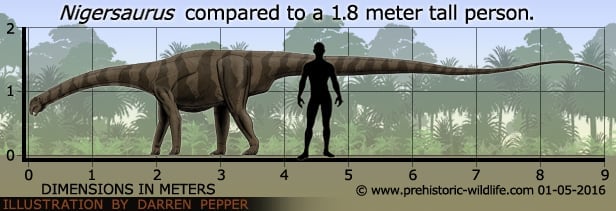
Nigersaurus was a very specialised sauropod, evolved for feeding as a low browser.
To accomplish this, the skull was shaped so that the jaws formed a very broad, flat edge across the front maximising the amount of vegetation gathered in a single bite.
Inside these jaws were hundreds of teeth arranged in a single straight line near the edge of the mouth that would have been ideal for cropping very low vegetation with little effort.
A further adaption is the structure of the inner ear that indicates that the head was usually carried in the down position so that the front of the mouth was always presented towards the ground where its choice food supply was.
Further Reading
– Cretaceous sauropods from the Sahara and the uneven rate of skeletal evolution among dinosaurs – Science 286 (5443): 1342–1347 – P. C. Sereno, A. L. Beck, D. B. Dutheil, H. C. Larsson, G. H. Lyon, B.Moussa, R. W. Sadleir, C. A. Sidor, D. J. Varricchio, G. P. Wilson & J. A. Wilson – 1999. – Structural Extremes in a Cretaceous Dinosaur – PLoS ONE 2 (11): e1230 – P. C. Sereno, J. A. Wilson, L. M. Witmer, J. A. Whitlock, A. Maga, O. Ide, T. A. Rowe – 2007.